About The Expedition
The International student's web expedition (Class@Baikal) starts with a one-day introductory conference-webinar in Irkutsk which is devoted to modern problems of geology and ecology of the largest fresh-water lake of the planet. Researchers, professors and students of several faculties of the Lomonosov Moscow State University (MSU), the Limnological Institute of the Siberian Branch of the Russian Academy of Science, the Irkutsk State Technical University, the University of Oslo and the Pierre and Marie Curie University of Paris take a part in this meeting. Presentations and discussions will be broadcasted in the Internet. Russian and European students will have a chance to join the conference following its web broadcasting on their PCs from everywhere. In addition, MSU invites everyone interested in this conference to special room of video conferencing where the direct teleconference with Irkutsk will be organized.
The main part of the web expedition will be carried out during the period from July 12 to July 24, 2014 onboard of the research vessel “G.Yu.Vereshchagin” in the waters of Baikal Lake. In the course of the expedition it is planned to investigate unique natural processes at the bottom of the Baikal Lake, a large recent submarine slide body around the Kukuy Griva (crest) and the Novosibirsk mud volcano. Participants of the expedition will get acquainted with modern methods of geological, geophysical and geochemical studies of bottom sediments, will understand in practice how to work with the equipment for bottom sampling, underwater video observations and seismic profiling, will learn how to select, describe and preserve samples of bottom sediments, gases, gas hydrates and fauna in laboratories of the vessel. Every day the participants will prepare and upload on the special website the detailed and illustrated report on the works carried-out during the day. Reading and following these daily reports more students and other interested people can “join” the expedition.
Also during the expedition, daily scientific and training lectures and seminars will be given onboard the ship. All materials of lectures and seminars will appear on our website every day.
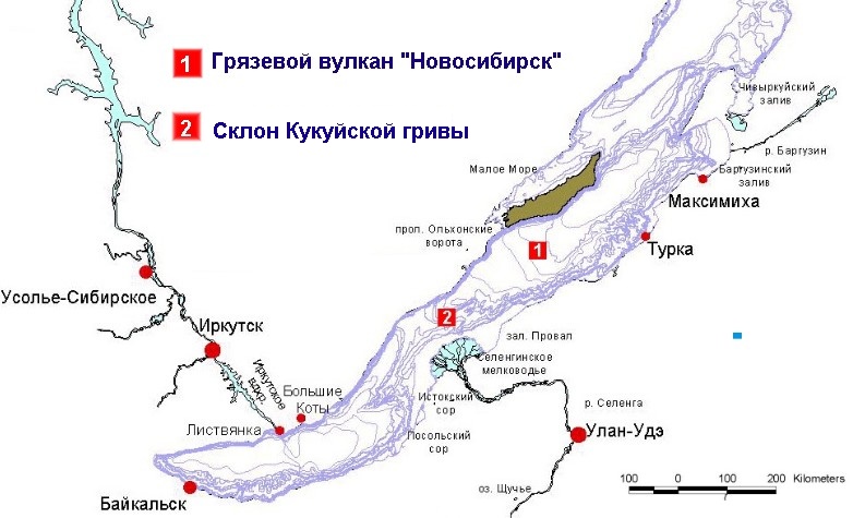
Area A. Novosibirsk Mud Volcano
History Of Studies
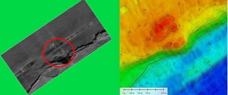
In the framework of the INTAS project, in 2002, the Russian-Belgian geophysical expedition in the waters of Baikal Lake was organized. For the first time two new positive structures located on well-expressed seafloor terrace in the central depression of the lake were mapped and studied during side-scan sonar survey (Group “Sonnic”, St. Petersburg) and seismic and acoustic profiling (team from the Institute of oil and gas geology and geophysics of the Siberian Branch of the Russian Academy of Science, Novosibirsk). Discovered features were interpreted as mud volcanic edifices. One of them was named the Novosibirsk mud volcano. During further studies the assumption of the mud-volcanic nature of the structure "Novosibirsk" was confirmed completely.
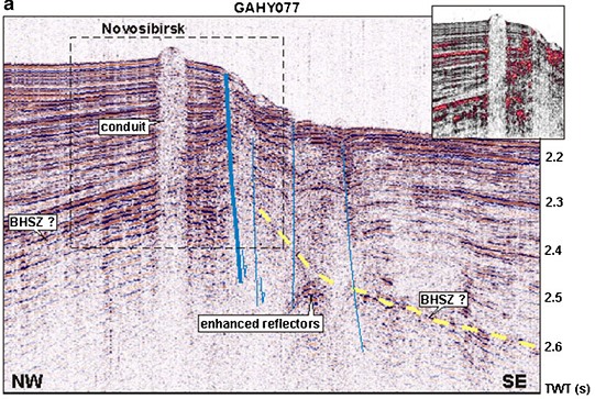
Description Of The Object
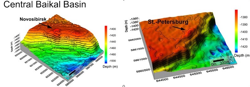
The Novosibirsk mud volcano is well expressed in a relief of Baikal bottom and it is located on the uplifted wing of tectonic fault. Water depth in this area is about 1405 m, height of the mud volcano is 15 m, and diameter is about 1200 m. The feeding channel (probably, gas saturated) is well expressed on seismic profile. Mud volcanic breccia (with gas hydrates) was recovered during bottom sampling.
Objectives Of The Expedition
During the expedition it is planned to make an extensive bottom sampling of recent sediments (up to 8 sampling stations every day) with the use of gravity core and grab sampler. The recovered sediment sections will be described in details and photographed. The cores will be subsampled and samples of sediments, pore waters, gases and fauna will be sent for detailed studying in MSU and laboratories of the Limnological Institute of the Siberian Branch of the Russian Academy of Science. It is planned to classify bottom sediments into different types, to analyze mud volcanic breccias (clayey matrix and fragments of rocks).
Among scientific tasks, there are studying of the mechanism of formation of a mud volcanic breccia, determination of a depth of roots of the mud volcano; analysis of history of mud eruptions and recent activity of structure; clarification of the nature of gas flows, their intensity and structure; the analysis of the authigenic mineral transformations and diagenesis connected with zones of gas and fluid seepages at the bottom of fresh-water lake. In the long term it is planned to use the obtained data for the comparative characteristic of marine and Baikal mud volcanoes. It will allow getting closer to understanding of the nature of mud volcanism, to find out the general planetary regularities of this natural phenomenon and to define the specific characteristics reflecting localization and evolution of certain mud volcanic edifices.
Pictures from the article:
Cuylaerts M.,, Naudts L., Casier R., Khabuev A.V., Belousov O.V., Kononov E.E., Khlystov O.M., De Batist M. Distribution and morphology of mud volcanoes and other fluid flow-related lake-bed structures in Lake Baikal, Russia. // Geo-Marine Letters. 2012; 32(5):383-394
Area B. Slope of the Kukuy Griva (crest)
History Of Studies
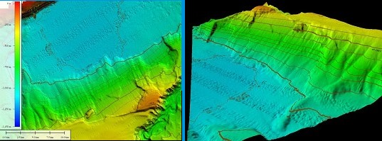
The new high resolution bathymetric data were obtained by researchers of the Limnological Institute of the Siberian Branch of the Russian Academy of Science in co-operation with the Belgian scientists from the University of Ghent (RCMG) during the multi-beam survey in the central depression of Lake Baikal in 2009 (in the framework of the Program of the Russian Academy of Sciences 17.8 and the FWO Flanders (1.5.198.09). The analysis of the relief showed that on the northwest slope of the Kukuy Griva (a large underwater hill) a large landslide body can be distinguished. The location of the upper edge of the landslide along an isobath of 360 m (the upper level of gas hydrate stability zone on Baikal) might serve as indirect evidence that this landslide was formed in the recent past during the destruction of hydrates resulting from decreasing in water level of the lake.
Description Of The Object
The maximum width of the landslide body is about 3 km, the attitude of slump escarpment is 100–120 m. The landslide moved and deformed the significant volume of sediments in the central part of the crest.
Objectives Of The Expedition
During the expedition it is planned to accomplish the complex of geological, geochemical and geophysical surveys focused on studying of the structure of the landslide body, the analysis of possible reasons of sliding and the forecasting of development of the landslide. Seismic and acoustic profiling and bottom sampling are planned. Samples of sediments, pore-waters and gases will be collected. Detailed sedimentological mapping and studying of structure of sediments in different parts of the landslide body might allow defining age of sliding and its reason. The main objectives of the expedition include: to search for evidences of gas and fluid saturation of sediments and gas hydrate bearing; to describe present-day slump deformations in sediments; to analyze the reasons of slope instability; and to define connection of slope instability with gas and fluid saturation of sediments. It is planned to make the analysis of the processes initiated by the land-sliding (local turbidite formation, dissociation of gas hydrates and others); to study authigenic diagenetic transformations in recent sediments of different types (turbidites, slumped deposits, landslide escarpment, “pelagic” sediments, etc.) in fresh-water environment; to compare fresh-water diagenesis with typical marine diagenesis. In the long term the conducted examinations will allow to better understand the reasons and consequences of subaqueous sliding, and to localize areas of risky engineering activity on water areas more reliable.